Karl Harker
Agricultural Meteorologist - AWIS Weather Services
- Contents
- Using Dew Point Temperatures to Forecast Frost
- Inversion Strength - Using That Warm Air Above!
Will
You Be Ready for the Next Killer Freeze?
(back to top)
You and Your Forecast Nobody can control the weather and killer freezes are a fact of every producer's life. A good freeze/frost forecast delivers the information you need to prepare for these events. It saves you endless hours of channel surfing, radio listening, and web scanning. A complete freeze-frost package tells you when cold events are coming and how cold it will get. It should also included the duration of the cold event, the strength of any inversions, wet bulb temperatures, and wind speeds. These parameters allow you to decide how to best protect your crops. Our forecast service gives you the information you need to protect your operation. AWIS meteorologists call it straight and don't cry wolf, saving you time and money.
Irrigation Forecast temperatures, wind speeds, and wet bulb temperatures will help you apply water and determine its effectiveness. Wind speeds in excess of 5 mph for tree crops and 10 mph for low growing crops promote evaporative cooling and limit the effectiveness of irrigation. Wet bulb temperature is the best indicator of evaporative cooling. Irrigation should be applied before wet bulb temperatures reach critical temperatures. A forecast of the length of the freeze event helps you determine if you have sufficient water to protect plants. Insufficient water may cause devastating losses because of evaporative cooling. During long cold events, ice accumulation may also cause damage.
Row Covers and Tree Wraps Forecast temperatures and cold event durations will tell you how effective these measures will be. Row covers and tree wraps work by delaying, but not preventing, heat loss and are most effective during freezes of short duration. They are less effective during freezes when temperatures decrease slowly and remain low for long periods of time. Eventually, temperatures under wraps and covers will approach air temperature. The thicker (more insulating) the material is, the better the protection.
Heaters Forecast inversion strength and wind speeds are critical for heater use. Heaters are far more effective when inversions are present. The hot gases emitted from the top of the stack stir the air and mix the warm air above with the cool air below. A much smaller portion of the energy is released as radiation from the hot metal stack. Because this heat will reach any solid object in line-of-site, it provides some protection when wind speeds are higher and inversions are weak.
Wind Machines and Helicopters Inversion strength is critical. A temperature inversion of at least 5 F difference is necessary and an inversion of 10-15 F makes these cold protection methods very effective. Wind machines and helicopters should be started when air temperatures are two or three degrees above critical temperatures.
Wet Bulb Temperature
- What It Is and How to Use It
(back
to top)
What is Web Bulb Temperature? The wet bulb temperature is the temperature air cools to when water is added. We are all familiar with this phenomenon. You feel colder when you are 40 F and wet, than when you are at 40F and dry. A sling psychrometer is used to measure wet bulb temperatures. It consists of two thermometers, one measures the air temperature and the other measures web bulb temperature. The bulb of the web bulb thermometer is covered with a wet cotton sock. The sling psychrometer is swung in the open until the wet bulb temperature drops no further. Automated weather stations report wet bulb temperatures indirectly. It is usually calculated from air temperature and relative humidity measurements.
How Do You Use Wet Bulb Temperature? Many growers use water to protect crops from freezing temperatures. It works because when water freezes on plants it releases small amounts of heat. This heat keeps plant temperatures at 32 F, even when air temperatures are colder. What do wet bulb temperatures add to the picture? Wet bulb temperature is almost always lower than air temperature. In many cases it is considerably lower than air temperature. When water is applied to a crop, plant surface temperature initially drops to the wet bulb temperature, even when air temperatures are well above freezing. If the wet bulb temperature is 25 F, tender buds, growing points, fruits and shoots will experience 25 F. How long the temperature remains there depends on the speed of ice formation. This could range from minutes to hours. This initial 'cold jolt' can cause damage even when there is good ice formation.
The Bottom Line 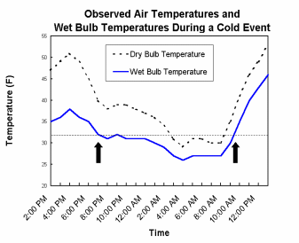
Wet bulb temperature should be used to determine when
to turn on and off water used for cold protection. Water
should be turned on before the web bulb temperature
reaches 32 F and turned off when it is about 32 F. The
figure illustrates observed wet and dry bulb temperature
in a cold event in Florida. The arrows indicate when
the water should have been turned on and off. If a grower
had waited until the air temperature reached 32 F, the
plant surfaces would have dropped to 27 F. In this case,
use of the wet bulb temperature extended the protection
period by nine hours and eliminated the 'cold jolt'.
(back to top)
You've probably heard that when La Nina conditions prevail winters are typically drier and warmer than normal. Does that mean that you won't have a killer freeze? Most certainly not! Freeze events can and often do occur during La Nina winters.
Consider this, La Nina winters normally result in colder and wetter than normal conditions over the Northern Plains states. That increases the possibility of a deeper than normal snow pack. A brief change in the upper atmosphere can easily bring down a shot of arctic air that has built up over the snowy/icy Northern Plains. That means a sudden temperature drop, a classic killer-freeze interrupts our nice warm, dry winter.
More importantly, freezes that occur during La Nina winters are often capable of inflicting more crop damage than similar freeze events occurring in other years. Crops don't harden-off in mild winters making them more susceptible to freeze damage.
Drier than normal soils in La Nina years also increase the risk of freezes for ground crops. Dry soils radiate heat more rapidly, thus resulting in colder temperatures at the ground surface when compared with wet soils. Just a few degrees difference around 32 F can make or break a crop.
A wise grower will keep these facts in mind as he prepares for a La Nina winter. Enjoy the weather, but keep your eye on it! Or better yet, get help from a professional forecasting service.
How to
Adjust the Forecast for your Terrain
(back
to top)
Even a great forecast may need some adjustment for the particulars of your location. This adjustment can mean the difference between cold damage and no damage. All Ag producers concerned with cold damage do this instinctively. Here are a few tips that might fine-tune your technique.
Minimum temperatures can vary by as much as 15 degrees at night over small distances. Some of the key factors that cause these differences are topography, soil conditions, and wind.
On nights with no wind and clear skies,
heavy cold air will roll or drain to valleys, creek/river
bottoms, and small depressions surrounded by higher
terrain. This can drop the temperature in low-lying
areas by several degrees. The temperature change is
most pronounced on nights when there is very little
wind and skies are clear.
Have you ever noticed frost on the lee sides of wind
breaks after cold nights with gentle winds? Colder temperatures
can prevail in areas downwind of trees, hills and buildings.
Lighter winds on the lee side of windbreaks make heat
radiation more effective. Less mixing of warm air above
and cold air below occurs. This effect is most pronounced
near the ground. This does not occur on extremely windy,
cold nights when the coldest temperatures are found
at the highest elevations.
Soil moisture can also influence minimum
temperatures. The water in wet soils helps retain heat
and will keep temperatures warmer. Conversely, dry soils
radiate heat more readily resulting in colder temperatures.
Tweaking the forecast for your unique situation is a
valuable skill for Ag producers. Knowing which areas
run hot and which run cold can help you distribute your
resources effectively.
Getting
the Most Help out of a Cold Forecast
(back
to top)
Getting a good freeze/frost forecast is half the battle, using it correctly is the other half. All freeze/frost forecasts do not result in the same operational actions for every grower. Now is a good time to review some of the factors that affect cold protection actions.
Know your crop. Protection effectiveness is a combination of the threshold tolerance of the crop and the effectiveness of the cold protection method in use. Most foliage crops have higher critical temperatures than fruit crops. It can be too late for one crop before another is in danger.
Understand the limitations of the protective measures. For instance, the density and material of crop covers and tree wraps result in varying degrees of protection. Read the labels and know what you are working with. A three-degree protection cover is of limited value if the temperature falls seven degrees below the crop threshold value.
Watch out for strong winds. Wind machines, helicopters, and heaters will be less effective in strong winds. These measures rely heavily on the presence of inversions (warm air above) to protect plants. They essentially mix warm air above with the cooler air at the surface, raising the temperature at the surface. You will get some protection from heaters, but much less than on a still night. If other measures are available (water or covers) you might want to use them. Strong winds can also hinder the laying of crop covers, increasing the labor and time required to place covers.
Watch the wet bulb temperatures and dew points if you are using water to protect. A drop in the dew point temperature results in evaporative cooling. The water must be turned on before the wet bulb temperature reaches the threshold temperature, even if air temperature is well above it. This can extend the time during which water is applied by several hours.
Keep an eye on the duration of the cold event. Extended periods of icing can cause significant damage with branches and leaves breaking under the weight of the ice. Wind will aggravate this problem.
Know the expected daytime temperatures when cold events extend over several nights. Crop covers need to be removed during the day in many cases to avoid damage resulting from heat. Warm days under wrap may also cause plants to break dormancy, making them even more sensitive to the cold night. Make sure adequate labor and supplies are available in cases where long periods of damaging weather conditions are expected.
If your forecaster is not giving you the above information, by all means, get another one. Air temperature is just not enough.
Using Dew
Point Temperatures to Forecast Frost
(back
to top)
Frost forms when moisture is adequate and freezing temperatures occur. Dew point temperature can be very useful to determine if frost will form. Simply put, dew point is the temperature at which the air is saturated with water. The higher the dew point, the more water in the air. Dew point is always less than the air temperature, unless the relative humidity is 100%, then the dew point is equal to the temperature.
As the air temperature cools on a winter night and approaches the dew point, the moisture in the air will condense out of the air and on to solid objects. The surface temperature of an object must be freezing in order for frost to form. Objects that radiate energy more efficiently tend to frost up first. Thin objects (leaves, small branches, shoots, etc.) frost quicker than thick objects. The ground, particularly when moist, does a relatively good job of holding heat, so frost damage tends to occur at the top of vegetation.
Frost can form when dew point temperatures and air temperatures are in the upper 30s. Patchy and scattered frost can occur in areas that typically run cold, low areas where cold air accumulates, the lee side of wind blocks, etc. In addition, dew point and temperature are measured at the standard height of five feet. It can be colder at ground level.
Prime dew point temperatures for widespread frost formation are in the upper 20s to lower 30s. When this occurs with freezing air temperatures, everything is in place for potentially heavy frost formation.
Frost formation is less likely with dew point temperatures below the mid 20s. There just isn't enough moisture in the air for significant frost formation, even if temperatures are below freezing.
The length of time conditions are favorable for frost formation determines the intensity of frost. The more time the dew point and air temperature hover around or below 30 degrees, the heavier the frost.
Dew point is not the entire story. Other factors also affect frost formation. Wind speeds above 5 MPH slow the radiational cooling of objects, inhibiting frost formation. Cloud cover reduces the effectiveness of radiational cooling. The thicker the cloud cover, the slower the cooling. Soils containing abundant water increase the risk for frost formation by putting more water into the equation, particularly in cases where the dew point temperature is in the mid 20s to mid 30s range. This may counteract the fact that wet soils retain heat better.
Forecast dew point temperature is a key factor in anticipating frost formation. While it does not necessarily give a conclusive answer, it will give you a significant 'heads-up' call. If you aren't getting dew point temperature from your current weather provider, you should be.
Inversion
Strength - Using That Warm Air Above!
(back
to top)
Inversion strength can have a large impact on the effectiveness of your cold protection methods. Heaters, wind machines and helicopters are all more effective when low level inversions are strong.
Light winds and clear skies favor the development of low level inversions. These same factors encourage radiational cooling. As the earth's surface loses heat, the air close to the ground cools faster than the air above. Under strong radiational cooling conditions, temperatures at ground level can be a full 10 degrees cooler than the air 100 to 200 ft. above. Occasionally, temperature differences of up to 15 degrees can occur.
The height of the inversion is affected by topography, inversion strength and other factors. Determining the height is important because the warmest air is at the top of the inversion. There are few locations with adequate air temperature measurements to determine the height of the inversion. The easiest way to determine this is to start a smoky fire and watch where the upward moving smoke levels off. The smoke levels off at the top of the inversion - the point where the temperature is warmest. Normally the top of the inversion is between 100 and 200 ft, but it can be lower. Be sure to follow all local regulations on open burning.
Heaters work more efficiently in the presence of strong inversions. The warm air rising from the heater mixes the air. Convection cells are formed, pushing the warm air above down to the ground.
Wind machines and helicopters are frequently used to bring the warmer air down closer to ground level. The closer the wind machine or helicopter is to the top of the inversion, the more successful the attempt will be to warm the air near ground level.
Only a portion of the inversion strength can be realized. However it only takes a few degrees to save or lose a crop!
Contact AWIS | About Us