AWIS Weather Data Quality Control Procedures
AWIS Weather Services provides the most checked and cleaned data available today. Our quality control procedures are paralleled by non one else in the business. We do not sell satellite derived estimated data points. AWIS provides quality real-world weather observations that are extensively checked by humans on a daily basis. Our professional meteorologists put eyes on every piece of data that is ingested into our databases. We are working for our clients 365 days a year to assure the highest quality possible in our data. Our daily quality control consists of three steps:
- Automated quality control procedures screen the data before they enter the database. These procedures detect suspicious dates, missing weather parameters, and values outside reasonable ranges. They ensure, for example, that the maximum temperature is higher than the minimum temperature and perform other statistical tests. Nearly all near real time weather observations are sent in a complex code. Hourly data is transmitted in METAR code, while daily observations are sent in SHEF code. Errors are frequently made in these coding systems. AWIS has automated the decoding and checking of METAR and SHEF observations and deals with most of the commonly made mistakes.
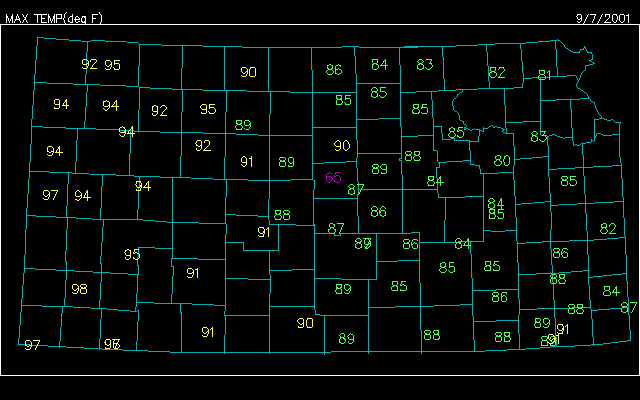
- In the next step, we use color-coded map displays to visually inspect for values that are outside of reasonable ranges (these are called outliers). Can you spot the outlier in the image above? Yes, this a manual step that takes time and experience to ensure that you get the highest quality Historical Weather Data from AWIS.
- The cleansed data are then used to create gridded fields of each weather parameter. Estimates from the gridded output are compared to the actual observations. Discrepancies are manually examined and corrected data are put into our database. Again, this is a manual step that helps us provide our clients with the best data available.
Here is just a small sample of the automated quality control checks of our daily weather data:
Potential errors for: ny
07 18 10 SLK   *** Precip Dif > 100 Obs: 124 Grid: 23|Elev: 1663 |#110 AM
07 18 10 WALN6 *** Min Dif > 10 Obs: 51 Grid: 62|Elev: 1240 |# 90 AM 24HR
We take elevation and observation time into account when reviewing potential errors.
Thousands of products are created after the above procedures are completed. If clients require products before quality control procedures are completed, preliminary products can be created and delivered. Updates are delivered after the quality control is completed.
Missing hourly data are estimated automatically when a single hour is missing. If several hours are missing the data may be estimated by one of our meteorologists. Missing parameters may also be estimated from gridded output.